Great Britain & NI
Showing 1–32 of 51 results
-

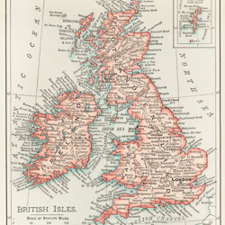
A cartographic map of the British Isles by Vintage Maps
$16.00 Add to cart -

A new and accurate map of the country for twenty five miles round the University of Oxford 1805 by G Pawley and Samuel John Neele
$16.00 Add to cart -

A new map of England 1811 by John Cary
$16.00 Add to cart -

Anthropomorphic Map of England by Vintage Maps
$16.00 Add to cart -

Anthropomorphic Map of Scotland by Vintage Maps
$16.00 Add to cart -

Anthropomorphic Map of Wales by Vintage Maps
$16.00 Add to cart -

Britannia by John Speed
$16.00 Add to cart -

British Islands approximate positions of minefields 1918 by William Rea Furlong
$16.00 Add to cart -

British Isles Waves High Water and Tides by Vintage Maps
$16.00 Add to cart -

England 1844 by Vintage Maps
$16.00 Add to cart -

England 1849 by Vintage Maps
$16.00 Add to cart -

England and Wales 1817 by Vintage Maps
$16.00 Add to cart -

England and Wales 1862 by Vintage Maps
$16.00 Add to cart -

England, Bristol by Braun Hogenberg
$16.00 Add to cart -

England, Canterbury by Braun Hogenberg
$16.00 Add to cart -

England, Lancaster by Braun Hogenberg
$16.00 Add to cart -

England, London 1860 by Vintage Maps
$16.00 Add to cart -

England, Norwich by Braun Hogenberg
$16.00 Add to cart -

England, Richmond by Braun Hogenberg
$16.00 Add to cart -

England, Survey of London Westminster and Southwark 1700 by Anna Beeck
$16.00 Add to cart -

England, Whitbreads new plan of London drawn from authentic survey 1853 by J Whitbread
$16.00 Add to cart -

Gazetteer of the British Isles, statistical and topographical 1887 by John Bartholomew
$16.00 Add to cart -

Geography of the British Isles 1886 by Thomas McLaren Davidson
$16.00 Add to cart -

Hiberia or Ireland 1598 by Vintage Maps
$16.00 Add to cart -

Home Rule Map of Ireland 1893 by Vintage Maps
$16.00 Add to cart -

Ireland 1665 by Vintage Maps
$16.00 Add to cart -

Ireland 1750 by Vintage Maps
$16.00 Add to cart -

Ireland 1817 by Vintage Maps
$16.00 Add to cart -

Ireland 1844 by Vintage Maps
$16.00 Add to cart -

Ireland 1849 by Vintage Maps
$16.00 Add to cart -

Ireland and Scotland 1862 by Vintage Maps
$16.00 Add to cart -

Ireland from the Gazetteer of the British Isles 1887 by John Bartholomew
$16.00 Add to cart